On August 25th the boys and I headed to Barclay Lake off of Highway 2 near Baring. We were all in the mood for an easy hike today and according to my sources, this was an easy one. With a distance of 4 1/2 miles and only 200 ft. of elevation gain this one seemed to fit the bill. It took us 1 hour to hike to the lake and about 50 minutes to get back to the trailhead.
Although this hike wasn't too steep, the path was rocky and had exposed roots in many spots. I felt it was closer to moderate in difficulty for little feet.
We entered the trailhead and immediately were enveloped by the trees.
The most interesting part of this hike for us were the huge rocks that had trees growing around them. There were many of them and it is not something you see every day.
The boys even climbed to the top of one.
You can tell that this forest has a high amount of precipitation by the moss that covers pretty much everything. It is like a lush green carpet.
About 1/2 mile from the Lake you will cross the bridge over Barclay Creek. We passed a huge crowd of people lingering here on their way back to the trailhead.
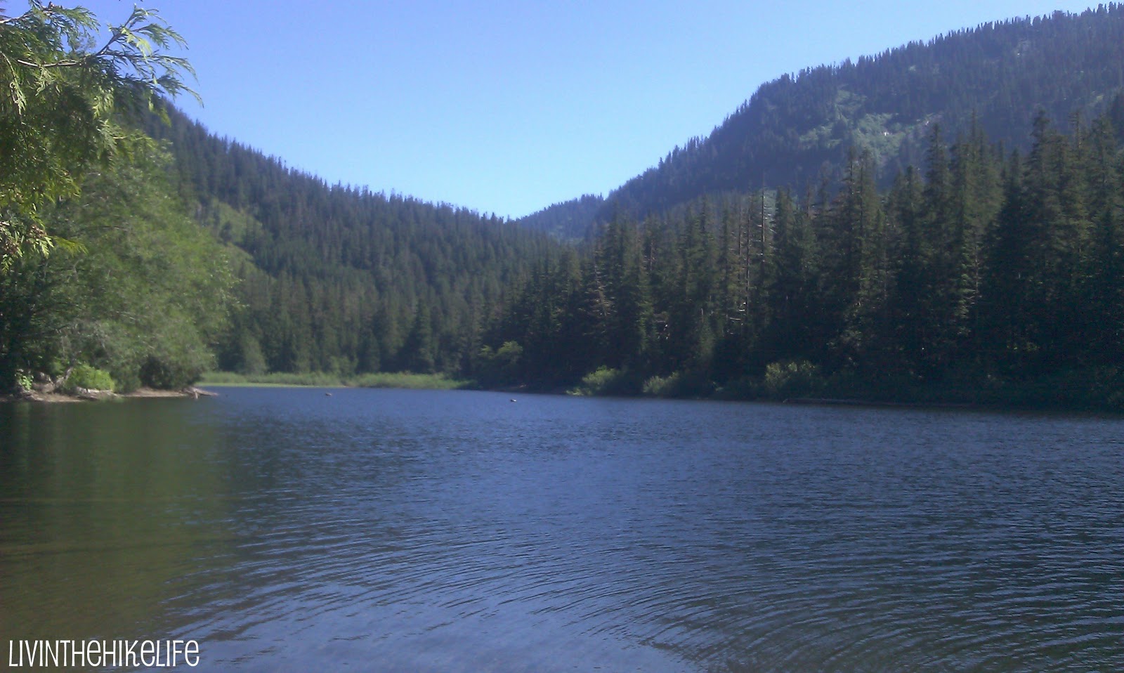
Walk a little further and you will reach Barclay Lake. This is a popular camping area and you may pass people camping along the way. Continue along the path and find your own secluded beach area. Lucky for us, we got a late start and most people were on their way down when we got there. We snagged a great spot on the lake and had a fun time playing in the water and having lunch. Make sure you bring your swim suits on a hot day.
The views on the lake were beautiful and you have a clear shot of Baring Mountain across the way.
This has become one of our favorite spots. I can envision ourselves coming in the morning and spending the entire day lounging and playing in the water. It was so relaxing, we didn't want to leave.
On the way back to the trailhead we stopped on the bridge to listen to the gurgling creek.
To get here you will drive East on Highway 2 to Baring. Turn left on 635th place (near milepost 41) crossing the railroad tracks. After .3 miles, you will turn left on forest road 6034. You are now on a gravel road and you will continue for about 4 miles to the trailhead. A forest pass is required to park at the trailhead. There are 2 honey buckets in the parking lot. One was out of toilet paper, luckily I had some in my hiking essentials kit.
Riley and I ventured to Goat Lake off of the Mountain Loop Highway near Darrington last week for a 10 1/2 mile hike. He was up for it and did an amazing job! While driving there I felt like we were seriously going into the middle of nowhere. This picture was shot from the dirt road leading to the trailhead.
I would rate this hike as medium in difficulty as far as the trail conditions and elevation with a gain of only 1300 feet. However, I would rate it hard as far as the distance traveled. So, I wouldn't recommend this hike for anyone under 9 years old.
The trail starts out in a new growth forest and you can hear Elliot Creek flowing after about a half mile. You will have to make a decision at the fork whether to take the upper or lower trail to Goat Lake. We took the lower trail to the lake and the upper on the way back. That way we didn't miss anything.
There were many blowdowns on the lower trail most of which didn't affect the trail.
Most of the way Riley and I could walk together, there are some areas where you will need to walk single file.
You will see some great waterfalls along the lower path.
At about 3.5 miles you will merge with the upper path and enter the old growth part of the forest. I love these ancient trees that have been standing so long. They are amazing!
I took so many pictures of these amazing trees and wish I could post them all. At about 4.5 miles you will see a dry creekbed and you will cross it to the right to enter the forest again.
You will then take a sharp left at this stump and head up the rocky hill.
A short while after the turn you will hear roaring McIntosh Falls and you can take a slight detour to view the falls. They are majestic.You are almost there. Just about 1/2 mile left. Right before you reach the lake you will see this sign and you will go straight to the lake.
After walking through a trail of greenery, you will finally reach the lake. It was definitely worth it.
We stayed here about 1/2 hour and had lunch before we had to head back down. It was so peaceful. We only saw 4 other people while we were there.
Now time to head back down. We went straight to the upper trail this time when we hit the fork.
The upper trail is like a whole different hike. The path was a bit narrow at some points.
Riley had to hold up this blown down tree for us to pass.
There was a rock slide about 1 mile into the upper trail that we had to go around, not too bad.
There were quite a few bugs. I used a bug repellent bracelet that didn't seem to work real well but probably was better than nothing. It took us 5 hours from start to finish including our lunch break at the lake. We would have stayed longer if we didn't have to drive an hour and a half to get back home.
To get here, drive the Mountain Loop Highway East from Granite Falls. You will pass the Verlot Ranger Station on the left. This hike does require a Forest Pass, so you can stop at the Ranger station if you don't already have one. Continue past the Ranger Station for about 19.5 miles to Barlow Pass (end of the paved road) and enter a gravel road. You will drive on this dirt road for about 4 miles and cross the Elliott Creek Bridge. About .2 miles after the bridge, you will turn right on road No. 4080 and drive for about a mile to the trailhead.
There is a great outhouse at the parking lot that seems pretty new. It smells of cedar which covers up any other bad smells that may linger. I had to add a picture. I love myself a nice bathroom. There was even a hand sanitizer dispenser that was full!
Overall, this was a great hike. Challenging distance, not too steep, and beautiful surroundings. The path was easily traversed and Riley was able to keep up with me no problem. The lake was spectacular and the views of Cadet Peak were snow capped.
This is one of my favorite places. The sculpture of wild horses atop the hill off of I-90 at Vantage is majestic and makes you feel like you are in a storybook. Going east on I-90 at Vantage, follow the signs to the parking lot and hike the steep hill about 1/4 mile to the top. There you will experience the beauty of these wild horses.
These views of the Columbia River and Canyons are amazing! Whenever I drive to Eastern Washington this is always my favorite spot.
This sculpture is over 20 years old and according to the sculptor, is only half finished. The horses are supposed to be set free from a large basket to symbolize free will.
The hill is a bit steep so I would not recommend going to the top unless you are sure of foot. Also step loudly to ward off rattlesnakes.
You can read the story of the sculpture built by David Govedare here .
Although this is not a long hike, this is a must see if you are in the area.
We decided to venture to Tiger Mountain in Issaquah, a very popular hiking destination, and hike the West Tiger #3 trail. This is a 6 mile hike roundtrip and it took us 3 1/2 hours to complete. I would say this hike is good for ages 8 and up just because of the length and the elevation gain. However, if you have an energetic younger child that likes to exercise, go for it!
Tiger Mountain is supposed to be hikeable most of the year. We went in August and trail conditions were great!
We didn't park at the trailhead parking lot so we hiked a short distance through the forest to our destination.
Woodpeckers anyone?
I would rate this hike as medium in difficulty. My children might disagree. The climb was uphill the entire 3 miles to the top with an elevation gain of 2100 ft. which was a bit tiring for the boys. The trail however, was wide and very well maintained.
There are several signs that point you in the right direction so the trail is easy to follow.
The hike through the forest was calming and peaceful and we enjoyed looking at all the scenery.
We even made a friend along the way.
There are a couple of nice viewpoints towards the top and it was great to reach the summit.
Unfortunately for us, we could not enjoy it for long due to the crowd of around 60 teenage boys at the top. They were a bit exuberant to say the least. Maybe a running club or something. Like I said, this is a popular hiking destination.
I would say this hike was a great one for the challenge, but the views at the top weren't the best I have seen. So, if you are looking for a great hike for the climb, this is a good choice. After all of the great hikes I have done with my boys, they were underwhelmed with the views at the top and my oldest son was expecting more for all of the work it took to get to there.
To get here drive I-90 east of Issaquah to Exit 20 (High Point). Go right and right again on Frontage Road (hard to see sign). You will see this sign. You can park here without a parking pass. There is a trail that leads from this spot to the actual trailhead that is .3 miles away.
If you would like to park at the trailhead, drive past this sign and follow a dirt road for less than a mile and you will reach the parking lot. A Discovery Pass is required to park here. Discovery Passes (I found out) are different than Northwest Forest Passes, so you will not be able to use your Forest pass here. They are $10 for a day pass or $30 for the year.
There are bathrooms just past the trailhead opening.
To get to the High Point just follow the West Tiger #3 signs. If you have hiked Tiger mountain, let me know what you thought. Happy Hiking!
While on vacation last week in North Idaho, we visited Q'emiln Park in Post Falls. This park includes a beach area, playground, boat launch, picnic area, and 40 acres of hiking trails along the Spokane River.
We went there to hike of course. There are 12 little hikes that make up 4 miles of trails. So, you can decide which way you want to go. Be careful though, the park skirts private property so watch out for the signs.
What these trails are really known for is rock climbing. Each separate trail goes to a rock climbing area and there were plenty of climbers when we were there. Next time we go we will be taking a climbing class.
There were blue metal signs at each off-shoot trail/climbing area that looked like this.
It's kind of hard to tell but there was a climber up at the top.
This was really fun to watch as we trekked through the forest. We made our way around most of the trails which were pretty easy.
Some were better maintained than others. This was a very kid friendly area if you stayed on the main paths. Some of the off-shoots were steep.
There were many beautiful viewpoints that overlooked the Spokane River and some amazing rock ledges.
We went off the beaten path a bit to make it down to the river. The water was crystal clear and there were 3 people on the entire river. We practically had the place all to ourselves. We put our feet in the water for a bit to cool off.
It was pretty hot while we were there and yes the boys had on their Camelbaks. I didn't have to listen to complaints of thirst the entire hike!
On the way back we went through a grassy area. Be sure to be loud with your footsteps to warn animals such as snakes. You want them to know you are there rather than surprise or scare them.
We enjoyed this hike and will bring our swimsuits next time to stay for a while at the river. I am used to a more out and back approach so this hike was a bit like a maze. Sometimes it was hard to remember if we went on a certain path already. Overall the views were nice and the river was peaceful. If you have children it is nice because you can do a hike and then head over to the park to play if you want.
The address is 12201 W. Parkway Dr., in Post Falls Idaho at S. end of Spokane St. bridge.
You do have to pay to park at the kiosk at the entrance. It is $3.50 per car, but there are quite a few free spaces right outside the park entrance along the road. This is where we parked. There are also bathroom facilities at the park as well as a port-a-potty at the trailhead.
I finally bought my boys each a Camelbak for our hikes. I chose to go with the Camelbak Classic 70 oz. Hydration Pack because of its simplicity and ease of use. This pack is basically just for hydration with no other bells and whistles which is perfect for the boys. The pack does have a small zippered pocket that will fit a small phone/key/snack. This pack holds about 4 bottles of water which is plenty, since the boys usually only drink 2 on our hikes.
We went on a hike yesterday and the boys used their Camelbaks for the first time. I have to say it was very freeing not to have to stop every time I heard "I'm thirsty". They were in charge of their own hydration and it was great! The boys were also happy to drink whenever they wanted without having to ask. Often on hikes they would want to stop for a drink and I would make them wait a bit longer. This way they can drink whenever they are thirsty.
Now I only have to carry water for me in my backpack which makes it much lighter! The boys even mentioned that they didn't even feel the packs on their backs which tells me they are comfortable and the weight from the water is well distributed.
Drinking is easy with the Camelbak since the tube runs from the pack and clips on the front of the strap. This makes it really easy to get to.
I shopped around a bit and found these packs on Amazon for about $39 each. Well worth the money and they shipped for free. They even made it to our house in about 4 days!
These packs are also easy to wash. The opening for water is large and easy to get into. I usually leave them upside down to drain when not in use. To clean I use Shaklee Dishwash Concentrate which is non-toxic and all natural. I prefer Shaklee products because I feel safe knowing my family isn't being exposed to harsh chemicals. The best part is that they work as well if not better than the harsher products I used to use and I don't get dizzy smelling the fumes.
I guess I might even need to buy one for myself. Happy Hiking!


